The tent was packed and our bellies were full with a carb- and protein- packed breakfast by the time dawn broke. The 2-hour drive ahead would take us on the scenic Takaka Valley Highway to the car park for the Abel Tasman hike—one of 9 New Zealand “Great Walks.”
Birgit and I decided to walk in part of the way from the end of the track to spend the night at one of its pristine beaches on Anapai Bay.
The two days we chose to do the hike were sunny and hot. Despite the sweaty conditions, the hike was enjoyable due to native bush shading the trail and sandy beaches with cool ocean water toeing at our boots.
The paradise-like features of Anapai beach and the comfortable camping conditions made Anapai Bay the best beach I have been to in all of New Zealand.
Takaka Valley Highway
Back on Route 6, Birgit and I drove Frogger up the windy road to the nearly 800 meter peak of Takaka Hill. Here, astounding 360-degree views included the Golden Bay’s Farewell Spit, the glacier-carved mountain valley of Kahurangi National Park, and the picturesque city of Nelson.
Takaka Hill itself is made up of marble and karst with many cave systems, sink holes, and river systems weaving through it. Takaka Hill claims the only place in the world other the Italy with marble outcrops and has been featured in scenes from the Lord of the Rings movies.
The native Maori people once believed the devil lived at the top of this hill. If you listen carefully, you can hear the hill grumble beneath you. The sounds are thought to come from the drainage through the hill in the cave systems below.
From Wainui Bay
We backed Frogger into a space in the shade and strapped our packs to our backs. We were loaded with camping gear, food, and water for our 10-15km trek along the coast of Abel Tasman National Park.
The technical end point of the non-loop crossing marked the start of our journey. This would put us closest to our destination and at the highest peak on the track in the early morning hours. It would be mostly downhill to Anapai Bay from there.
The incline
Completely exposed to the sharp sunlight, the path zig-zagged steadily upward along the edge of the cliff along Wainui Bay. Native forest to our right was loud with the sound of cicadas. To the left, waves folded smoothly into shore.
After about an hour, we reached the highest point. A bench overlooking Wainui welcomed us to plop our bags and take in the clear blue water and bright green forest of the bay.
Guardians of the forest
As we headed down the other side of the peak, we were shaded by the native trees and shrubbery of the forest. There was a hut where the land leveled off and then we emerged into a less dense portion of the forest in the valley.
This led to a small sand beach where hikers had built small shelters from the sun out of driftwood.
Continuing on, we walked through thick forest uphill then downhill then uphill again. Around inlets and out of bays we weaved, all the while listening to the ear shattering sound of cicadas all around us.
At one point, there were so many of cicadas we were in the way of their flight path! As if on a suicide mission, they kamikaze’ed into my head and pelted my arms like sideways hail. It was more annoying than painful. Whenever this happened we would quicken our pace to get to less densely forested areas. After all, this was their territory we had invaded.
Whariwharangi bay was in view as we mounted the next peak then made our way down into Mutton Cove. There’s a campsite at Mutton Cove with picnic tables perfect for taking a break for lunch. Our camp for the night was only a little further.
Anapai Beach
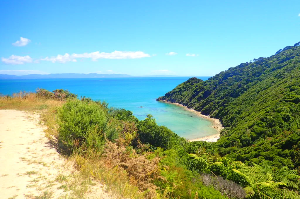
We approached Little Anapai—a smaller golden beach with a small, rocky peninsula forming a barrier between it and the main beach on the other side. The salty waves licked our boots as we dug our heels into the loose sand, marching toward the forested area behind the peninsula.
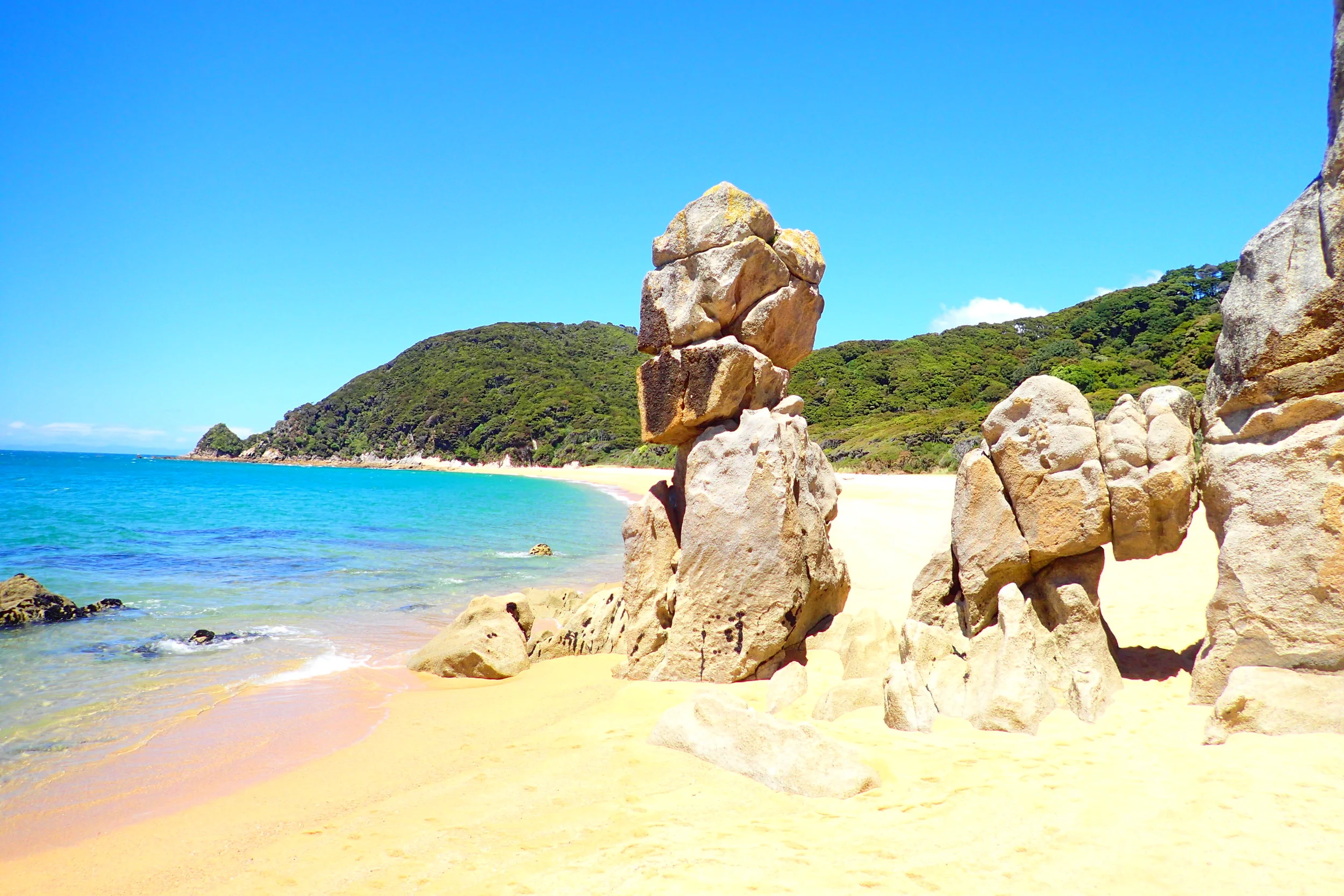
A short walk over the hill through the bush gave us a glimpse at the unusual beach awaiting us on the other side. Huge rock towers jutted out of the sand forming a sectioned off portion of the beach; a perfect lagoon for swimming. Some hikers climbed down to it from this halfway point, but we knew we’d get to experience the full effect camping nearby for the next 24 hours.
At about 4.5 hours into the hike, we made it to the campsite on the other side. The camp area was halfway down and behind the beach passed the famous rock pillars. These formations are responsible for making Anapai the most dramatic beach in all of Abel Tasman. They’re the reason we booked this campsite over others.
I spent the afternoon in the little lagoon, climbing on the rocks and carefully picking my way across the sharp layer of mussels. I swam the cool, clear water and watched as is splashed onto the pink and yellow sand. This was paradise!
I spent the whole day swimming and lounging in the sun. Then Birgit and I munched on the sandwiches we made for dinner the night before as we gazed out at the bay.
I couldn’t help but recall the beaches in Thailand. Was this more beautiful than the beaches on Ko Tao? When it’s difficult to decide which were the best destinations and experiences during your travels, it means you’re winning.
Sheltered camping
After dinner, we watched the sunset and then tucked into our tent which was pitched only a few short paces behind the sandy beach.
Thick kanuka and mahoe shrubbery shaded the tent from the intense New Zealand sun during the day. Otherwise the weather was perfectly calm and the temperature comfortable for sleeping after sundown.
Anapai was the Goldie Locks of campsites—everything was juuuuuust right.
Huts are available all along the track, but staying enclosed in a wooden cabin with some 20-odd other hikers and few amenities does not appeal to me. Why bother if you have the option to sleep right next to the beach listening to the light breeze brush across the leaves in the canopy above.
I'll prefer this view...
Over this view...
Heading back
By morning, the tide had submerged the rock formations and small inlet I had swam in the day before. I would have given it another swim, but I didn’t want to be wet for the hike back. We spent some time sitting on the sand, saying goodbye to the gorgeous Anapai beach. But then it was time to return to the car park. Frogger was waiting.
After the hike, we stopped in the town of Motueka for a much needed hostel-stay. We had not stayed at a hostel once yet and we were a full week into our 10-day journey. We deserved a hot shower, bed, and kitchen-prepped food. One always appreciates these simple things after a long hike and many days in a row of camping.
Hiking part of the Abel Tasman Great Walk was challenging, but definitely much less strenuous than the Tongariro Great Walk. We had cut back on the hiking distance significantly. Abel Tasman is actually about 15 km longer than Tongariro. But I think the hills and terrain are much more easily traversed than the volcanic wasteland of Tongariro.
The Abel Tasman was a very enjoyable hike, easy on the feet, and visually awesome in terms of the beaches. You can’t get better beaches in New Zealand!